OPPOSITION TO A NEW QUARRY FOR FISH CREEK
Background
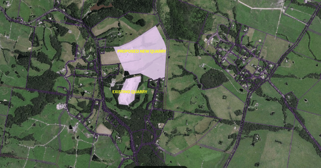
The current Fish Creek quarry has been operating since 1995, supplying crushed mudrock to local farms for driveways and property tracks. The quarry started as a gravel pit and expanded into a quarry and now covers an area of 500m x 300m and is 80m deep. At the current rate of extraction the current quarry site is expected to run out of rock by 2030.
The new quarry proposal
In 2024 the existing quarry owners lodged a proposal to develop a new quarry. This new quarry is not an extension but is in fact a new quarry approximately 4 times the size of the existing quarry.
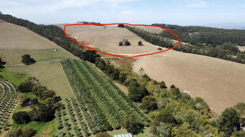
The proposal is to locate the new quarry adjacent to the protected Hoddle Range Nature Reserve. This aerial photo provides a perspective of the proposed quarry compared to the existing one.
This proposal should concern everyone with an interest in maintaining the ecological, agricultural and tourism significance of the unique Prom Coast region.
OUR CONCERNS
Tourism Eyesore
This proposed quarry is on top of a prominent hill along the Hoddle Range. It is not down in a gully out of sight as the current quarry is. It will be clearly visible from most vantage points from the Hoddle Range and from many points along the Hoddle Mountain Trail. It will be clearly visible from Mount Nicoll Nature Trail. Most importantly it will be clearly visible from the Meeniyan – Promontory Road – the main tourist road to Wilsons Promontory.
As visitors approach the most revered National Park in Victoria, they will pass multiple 20 tonne dump truck and trailer loads whilst driving on one of Victorias most dangerous roads. Their scenic views will include a full scale open mine eyesore within 10 minutes of the gateway to Wilsons Prom.
Residential Impact
In 1995 the surrounding properties were primarily farmland. Since then the area has been rezoned by South Gippsland Shire as ‘rural residential’ following application by the current quarry operator. Many residents now live in the area surrounding the proposed quarry site – many having purchased their land from the current quarry operator in the knowledge that the existing quarry has a defined boundary.
The existing quarry is now an 80m deep pit and is surrounded by trees planted more than 25 years ago and is largely invisible. The new quarry is at the top of a hill and has no trees around it to diffuse dust and noise. It will be visible from many kilometres away, impacting the views of Wilsons Promontory from Hoddle Range and Mount Nicoll , effectively destroying the natural beauty of this pristine region.
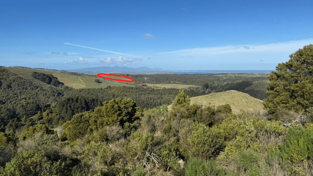
This is a view from the Hoddle Range looking toward Wilsons Prom. The red marked area is the site for the proposed quarry.
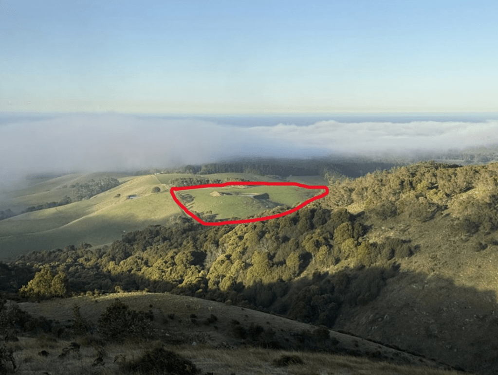
This view of the proposed quarry site, taken approximately 2km away from the Hoddle Mountain Trail above Battery Creek Reservoir, demonstrates that the open cut quarry will be clearly visible from almost anywhere along the Hoddle Ridge.
Noise & Amenity – No Assessment
Quarry crushing generates 70-90dB(A) at source. No accoustic assessment has been provided. The Alpine Shire VCAT refused a quarry for this single deficiency in June 2025. The area’s rural character and tourism economy depend on the amenity a quarry would destroy.
Agricultural Businesses Threatened
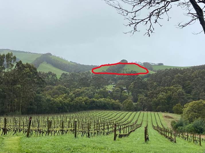
This view from Waratah Hills Winery looking north show the proposed mine site circled in red which will be clearly visible from the vineyard and cellar door. Research documents grape yield reductions of well over 20% from quarry dust.
This view from above the Golden Creek Olive Farm shows how dangerously close the new quarry will be to this long established agricultural business. EPA’s required 500m separation has clearly not been established.
Dividing Creek Honey is the third agricultural business in the immediate area surrounding the proposed new quarry site. None of these businesses have been consulted. All of these business will be severely impacted if this quarry was to proceed.
Crystalline Silica – A Health Crisis
The mudstone mined at the current and proposed quarry contains 10-30% crystalline silica, classified by IARC as a Group 1 carcinogen causing silicosis, COPD and lung cancer. The Safe Work Australia model code of practice (Nov 2025) mandates air monitoring, health suveillance and a silica risk control plan. None exist at the existing quarry (WA495). Adjacent residents & businesses and their employees are exposed 24/7 with no protection.
Silica dust legislation is relatively recent (November 2025) however to date no safety procedures or content measurement has been implemented at Fish Creek Quarries.
Failure to comply with State Government extraction guidelines
This proposal has shone a light on the current quarry operations and raises many questions about safety for both workers and nearby residents. The attached document from the State Government outlines the requirements for both the existing quarry and the quarry proposal.
Not Strategically Significant
The Victorian Government’s Strategic Extractive Resource Areas (SERA) program identifies which resources matter. Mudstone is used for dairy track sheeting and residential driveways and is not classified as strategic. Crushed gravel and limestone outperform mudstone for this purpose.
Research into this proposal has brought to light many concerns with the existing quarry (WA495). Unfiltered silica dust, excessive noise, unsafe road use, silt runoff, wildlife impact, the impact on local businesses are all issues that require further investigation by authorities.
Road Safety only 1 star at Quarry entrance
AusRAP goverment date rates the Quarry entrance section of Meeniyan-Promontory Road at 1.0 star – the absolute floor of road safety. The whole corridor averages 1.6 stars. Well below the standard required for a road carrying the traffic this road carries.
In May 2023 a school bus carrying 16 children was run off the road by a truck & trailer. This road is not built to handle the existing heavy vehicles and certainly cannot handle more. Victoria’s Safe System target is 3 star minimum. None of this road meets this standard. No traffic impact assessment has been undertaken. This road needs to be widened and improved to handle the current truck traffic. It is certainly unable to handle more traffic in its current parlous state.
Of course this road issue is not the responsibility of the Quarry operators but its an issue that needs to be addressed by VicRoads. More Info
Threatened Species at Risk
Independent Research identified 92+ species threatened, near threatened and migratory species within 5km – the proponent found only 26. Key species are the Strzelecki Koala (only genetically intact Victorian population ~1500-2000 remaining), Gang Gang Cockatoo (threatened species and protected under the EPBC) and three migratory species triggering mandatory EPBC Act referral.
Irreversible Environmental Damage
Arguably Victoria’s most environmentally important natural corridor, adjacent to Wilsons Promontory National Park, Cape Liptrap National Park and the Hoddle Range Conservation Area.
These natural landscapes are of crucial significance and ecological importance to all Australians.
This is a new quarry, not an extension of the existing quarry. It is on top of a range, adjacent to Hoddle Reserve and totally exposed. It is 4 times the size of the existing quarry, 800m x 300m and it will extract rock for 80 years at the potential rate of more than 100 trucks a day.
There are many alternative sources of rock on the region that are located out of site, appropriately distanced from residential zoning and that are not impacting the environment in the way this one will.
Do we really want a new open cut mine operating on top of a hill in the centre of this land we cherish so deeply?


This website has been prepared by Prom Coast Guardians. We are a connected group of residents, businesses, visitors and landowners concerned about the protection of our natural environment with a focus on the Hoddle Range and Wilsons Promontory region of South Gippsland.
